Home » Company
Company highlights
| Table Header | Table Header | |
|---|---|---|
| Name: | ΓεωΑνάλυση Α.Ε. | |
| Distinctive Title: | GeoAnalysi S.A. | |
| Member of: | Technical Chamber of Greece | |
| Year of establishment: | 1988 | |
| Head office: | Thessaloniki | |
| Branches: | Athens, Kozani, Xanthi | |
| Chairman: | Kyriakos Savvidis | |
| Table Header | Table Header | |
|---|---|---|
| Executive Manager: | George Alexander Savvidis | |
| Share Capital: | € 1.667.712 | |
| Quality Management System: |
ISO 9001:2015 ISO / IEC 27001:2013 ISO 14001:2015 ISO 22301:2019 | |
| Study Reg. No.: | 274 | |
| PHARE Reg. No.: | ELL 22117 | |
Quality in our Services
The strong point and the key to the company’s success has always been the perfect organization of all levels of service provision. And its commitment to quality assurance issues. Thus, it became the first engineering company in Greece to be certified according to the international ISO 9001 standard in 1997, which has remained in force ever since.
Investing all these years in matters of quality and safety, GEOANALYSIS S.A. developed a powerful, particularly dynamic, and modern Quality Management and Information Security System, which complies and is certified according to international standards (ISO 9001, ISO 14001, ISO 27001/27701, ISO 22301, ISO 37001, ISO 45001). The management of the company gives special importance and priority to the satisfaction of its customers’ requirements, and the continuous improvement of the quality of its services, as reflected in the quality policy.

Corporate milestone
| Table header | Table header |
|---|---|
| 2020 | Undertake of the National Cadastre Project for Cyclades island group |
| 2018 | Undertaking 3 Contracts for the study of the National Land Registry in the Prefectures of Drama, Xanthi, Chalkidiki, Kastoria, Florina |
| 2017 | Undertake of the Archaeological Cadastre |
| 2014 | Undertake of the monitoring and evaluation of the conservation status of community interest mammal species in Greece |
| 2013 | Approval of investment project in the field of diagnosis of diseases, protection and management of the rural environment (Mediterranean olive trees - eleagro service) |
| 2013 | Undertake of the National Cadastre Project of whole Kozani Prefecture (Ktimatologio S.A) Approval of investment project in the field of diagnosis of diseases, protection and management of the rural environment (Mediterranean olive trees - eleagro service) |
| 2012 | Undertake of the National Cadastre Project of whole Kozani Prefecture (Ktimatologio S.A) |
| 2012 | Upgrade of the Quality Assurance System to ISO 9001:2008 |
| 2009 | Growth of services in the field of energy |
| 2008 | Growth of services in the field of agriculture (optimisation, forecasts, precision agriculture) |
| 2007 | Growth in activities at Eastern Europe Countries and Cyprus |
| 2007 | Renewal of the company equipment under the frame of four contracts in the National Cadastre |
| 2002 | 2002 Certification of the Software Development and the Legal Support for the National Cadastre Departments according to the ISO 9001:2000 international standard |
| 2002 | Upgrading of the quality assurance management system according to the ISO 9001:2000 international standard |
| 2001 | Certification of the Research and Development Department according to the ISO 9001 international standard |
| 2001 | Increase of share capital to 1.47 M€ |
| 2001 | Transfer of the headquarters to a new privately owned building located in Fοinikas, Thessaloniki |
| 1999 | Establishment of Xanthi branch |
| 1997 | Implementation of the quality assurance management system certified by the Hellenic National Standardisation Organization (ELOT) according to EN ISO 9001 international standard |
| 1997 | Establishment of Athens branch |
| 1991 | Establishment of the Thessaloniki branch and transfer of the headquarters |
| 1988 | Establishment of the company in Kozani |
Technological milestone
| Table header | Table header |
|---|---|
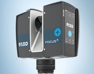
| 2020 | New Laser Scanner - FARO |
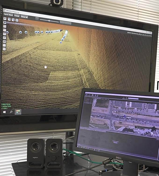
| 2019 | Development of Mobile Mapping System |
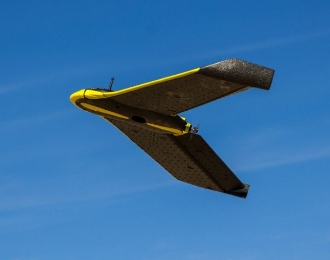
| 2015 | Services providing using unmanned aerial vehicle (UAV) system (eBee) |
| 2014 | Low altitude flights for the production of cadastral base maps of very high geometric accuracy with the use of Line Cameras. Aerial photography services with the use of thermal and hyperspectral sensors for monitoring the rural environment. |
| 2013 | Development of digital web-based platform for networking, continuous communication and information of large teams along with monitoring of projects in operational level. |
| 2013 | ΑνDevelopment of IT web platform for an integrated processing and management of cadastral data in OPEN environment -GEOKTHMA |
| 2012 | Service providing using Unmanned Aerial Vehicle (UAV) |
| 2011 | Computer vision and portable 3d color laser scanning for the high accuracy digitization, documentation and reconstruction of the Parthenon Frieze and votives |
| 2010 | Expansion of aerial photography service capabilities with the addition of a 6-canal multispectral camera |
| 2008 | Incorporation and use of 3d laser scanning technology in field surveying applications |
| 2006 | Launch of our e-shop and WEB-GIS for digital geographical data |
| 2003 | Launch of a spin-off company for the exploitation of the ecoMarble results (use of marble powder for the production of museum copies) |
| 2002 | Development of applications in WEB environment (document management, databases, GIS) |
| 2002 | Development of tools for the digitization of cultural objects of all sizes |
| 2001 | Use of high, network and telecommunication technology for the on-line connection of headquarters with branch offices |
| 2001 | Development of a set-up for aerial photography of archaeological sites and monuments based on a remote-controlled model helicopter |
| 1999 | Development of digital document management application |
| 1996 | Coordination of Research Projects funded by the European Commission |
| 1994 | Research on close-range and industrial photogrammetry funded by the Ministry of Development |
| 1992 | Introduction of digital photogrammetry |
Our Clients
Public Sector
Ministries
- of Dvelopment
- of Finances
- of Rural Development and Food
- of Culture and Tourism
- of Environment, Land Planning & Public Works
- of Environment and Climate Change
Public Enterprises
- Hellenic Cadastre
- EGNATIA ODOS S.A.
- Public Power Corporation S.A. – Hellas (PPC SA)
- Hellenic Telecommunications Organization (OTE SA)
- General Secretariat of National Statistic Service of Greece
- National Organization of Cadastre and Mapping
- GAIAOSE S.A.
- Institute of Geology and Mineral Exploration (IGME)
- Preservation of the Athonite Heritage
- Greek Public Real Estate Corporation
- Municipal Enterprise of Active Urban planning (DEPEPOK SA)
- Development Enterprise of Western Macedonia S.A.
- Development Enterprise of Florina Local Administration S.A.
- Local Business Support Bureau of Drama
- Waste management system of Western Macedonia S.A. (Diadima SA)
Regional administration
- Region of Central Macedonia
- Region of Eastern Macedonia – Thrace
- Region of Western Macedonia
- Region of Thessaly
Prefectural administration
- Prefectorial Local Government of Drama-Kavala-Xanthi
- Prefectorial Local Government of Evros-Rodopi
- Prefectorial Local Government of Imathia
- Prefectorial Local Government of Thessaloniki
- Prefectorial Local Government of Chalkidiki
- Prefectorial Local Government of Kastoria
- Prefectorial Local Government of Kozani
- Prefectorial Local Government of Florina
- Prefectorial Local Government of Dodecanese
- Prefectorial Local Government of Cyclades
- Prefectorial Local Government of Grevena
- Prefectorial Local Government of Korinthia
- Prefectorial Local Government of Drama
- Prefectorial Local Government of Viotia
Local Authorities
- Municipality of Ano Liossia
- Municipality of Vergina
- Municipality of Veria
- Municipality of Filippi
- Municipality of Dimitrios Ipsilantis
- Municipality of Kozani
- Municipality of Ptolemaida
- Municipality of Servia
- Municipality of Siatista
- Municipality of Vistonida
- Municipality of Xanthi
- Municipality of Topirou
- Municipality of Meliti
- Municipality of Komotini
- Municipality of Stavroupoli
- Municipality of Pylaia
- Community of Pentalofos
Ministries
- of Dvelopment
- of Finances
- of Rural Development and Food
- of Culture and Tourism
- of Environment, Land Planning & Public Works
- of Environment and Climate Change
Public Enterprises
- Hellenic Cadastre
- EGNATIA ODOS S.A.
- Public Power Corporation S.A. – Hellas (PPC SA)
- Hellenic Telecommunications Organization (OTE SA)
- General Secretariat of National Statistic Service of Greece
- National Organization of Cadastre and Mapping
- GAIAOSE S.A.
- Institute of Geology and Mineral Exploration (IGME)
- Preservation of the Athonite Heritage
- Greek Public Real Estate Corporation
- Municipal Enterprise of Active Urban planning (DEPEPOK SA)
- Development Enterprise of Western Macedonia S.A.
- Development Enterprise of Florina Local Administration S.A.
- Local Business Support Bureau of Drama
- Waste management system of Western Macedonia S.A. (Diadima SA)
Regional Administration
- Region of Central Macedonia
- Region of Eastern Macedonia – Thrace
- Region of Western Macedonia
- Region of Thessaly
Prefectural Administration
- Prefectorial Local Government of Drama-Kavala-Xanthi
- Prefectorial Local Government of Evros-Rodopi
- Prefectorial Local Government of Imathia
- Prefectorial Local Government of Thessaloniki
- Prefectorial Local Government of Chalkidiki
- Prefectorial Local Government of Kastoria
- Prefectorial Local Government of Kozani
- Prefectorial Local Government of Florina
- Prefectorial Local Government of Dodecanese
- Prefectorial Local Government of Cyclades
- Prefectorial Local Government of Grevena
- Prefectorial Local Government of Korinthia
- Prefectorial Local Government of Drama
- Prefectorial Local Government of Viotia
Local Authorities
- Municipality of Ano Liossia
- Municipality of Vergina
- Municipality of Veria
- Municipality of Filippi
- Municipality of Dimitrios Ipsilantis
- Municipality of Kozani
- Municipality of Ptolemaida
- Municipality of Servia
- Municipality of Siatista
- Municipality of Vistonida
- Municipality of Xanthi
- Municipality of Topirou
- Municipality of Meliti
- Municipality of Komotini
- Municipality of Stavroupoli
- Municipality of Pylaia
- Community of Pentalofos
Private Sector
- DORAL S.A.
- ΙΜΑ Gold
- PETRIS ATE
- TSANTALIS ATE
- TVX Hellas S.A.
- OLYMPIAKH TECHNIKH S.A.
- Malliakos-Kleidi Construction Associaton (MKC)
- Construction Association:
- Teachers and Kindergarten Teachers Municipality of Thessaloniki
- Machinery Operators Port of Thessaloniki
- Officers and Warrant Officers of Greek constabulary
- Engineers municipality of Kozani
- Blank clerk of Northen Greece
- METRO THESSALONIKIS
Equipment
Hardware
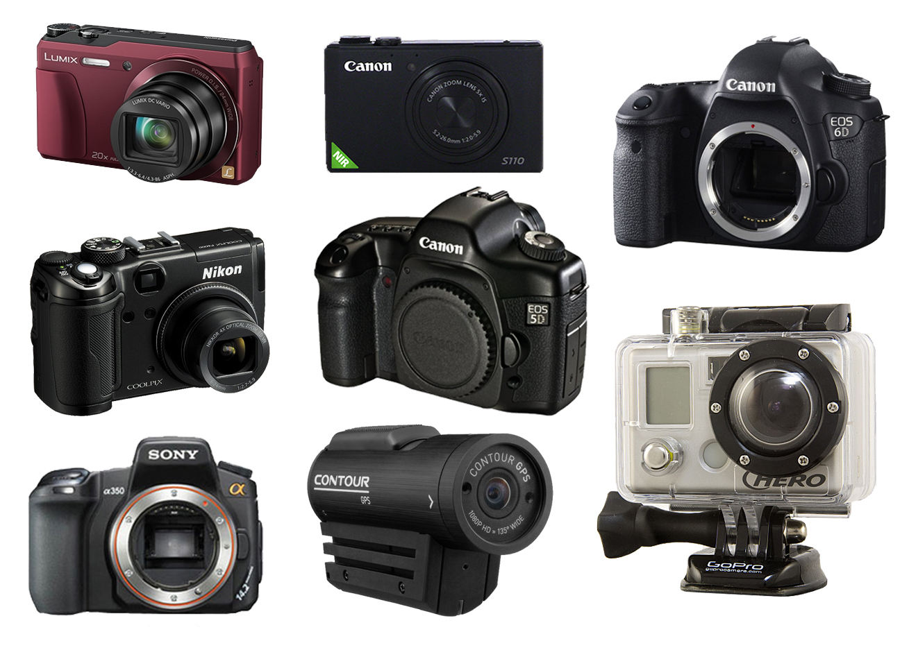
GEOANALYSIS S.A. stands out for its technologically perfect, state-of-the-art, and super-sufficient equipment, which makes it a pioneer company in the field. By constantly monitoring technological developments, the company evolves
and constantly renews its equipment in all areas of activity, offering unparalleled quality services. In the field of specialized mapping services, the company has invested in the new technologies of terrestrial, aerial, and underground mapping in two and three dimensions using appropriate sensors (multispectral, hyperspectral, and thermal cameras) and Mobile Mapping/SLAM, UAV/Laser Scanning systems, Terrestrial Scanning, Georadar, which has.
ANALYSIS S.A. among others, has invested the last 10 years in the field of scanning/digitizing documents and/or objects, having a very large number of specialized scanning systems, of various dimensions and types (2D and 3D) such as BookScanners, Handheld Scanners, etc.

Software
The processing of primary data and its management in the context of the offered and requested services is done using commercial software and/or open-source software developed by the company’s IT team. GEOANALYSIS S.A. has many commercial software specialized in the fields
- of surveying, road construction, and plumbing
- in design and 3D modeling
- in the management and processing of satellite images and aerial photographs
- in the development of GIS web-GIS and geoinformatics applications
- in 3D scanning and model editing
- in scanning, processing, automatic OCR recognition, and entering data into digital bases.

